|

Germany : Thüringen
3.0 km (1.9 miles) NW of Erfurt, Thüringen, Germany
Approx. altitude: 194 m
(636 ft)
([?] maps: Google MapQuest OpenStreetMap ConfluenceNavigator)
Antipode: 51°S 169°W
Accuracy: 20 m (65 ft)
Quality: good
Click on any of the images for the full-sized picture.


| 51°N 11°E (visit #3) | (secondary) |
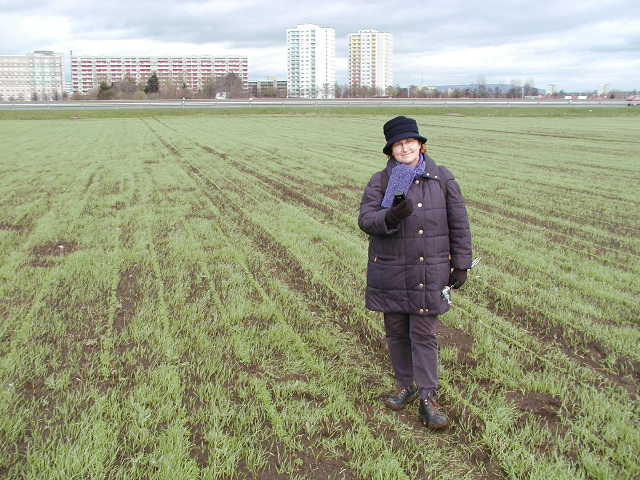
![Visit #20: [07-Oct-22]](/de/all/n51e011v20/preview.jpg "Visit #20: [07-Oct-22]")
![Visit #19: [06-Jun-22]](/de/all/n51e011v19/preview.jpg "Visit #19: [06-Jun-22]")
![Visit #17: [08-Aug-20]](/de/all/n51e011v17/preview.jpg "Visit #17: [08-Aug-20]")
![Visit #16: [20-Sep-15]](/de/all/n51e011v16/preview.jpg "Visit #16: [20-Sep-15]")
![Visit #15: [14-May-15]](/de/all/n51e011v15/preview.jpg "Visit #15: [14-May-15]")
![Visit #18: [27-Jul-13]](/de/all/n51e011v18/preview.jpg "Visit #18: [27-Jul-13]")
![Visit #14: [21-May-11]](/de/all/n51e011v14/preview.jpg "Visit #14: [21-May-11]")
![Visit #12: [16-Mar-10]](/de/all/n51e011v12/preview.jpg "Visit #12: [16-Mar-10]")
![Visit #11: [21-Dec-09]](/de/all/n51e011v11/preview.jpg "Visit #11: [21-Dec-09]")
![Visit #10: [28-Feb-09]](/de/all/n51e011v10/preview.jpg "Visit #10: [28-Feb-09]")
![Visit #9: [10-Aug-08]](/de/all/n51e011v9/preview.jpg "Visit #9: [10-Aug-08]")
![Visit #8: [14-May-06]](/de/all/n51e011v8/preview.jpg "Visit #8: [14-May-06]")
![Visit #7: [24-Jul-05]](/de/all/n51e011v7/preview.jpg "Visit #7: [24-Jul-05]")
![Visit #6: [29-Jun-05]](/de/all/n51e011v6/preview.jpg "Visit #6: [29-Jun-05]")
![Visit #5: [04-Jul-04]](/de/all/n51e011v5/preview.jpg "Visit #5: [04-Jul-04]")
![Visit #4: [09-Apr-04]](/de/all/n51e011v4/preview.jpg "Visit #4: [09-Apr-04]")
![Visit #2: [10-Nov-01]](/de/all/n51e011v2/preview.jpg "Visit #2: [10-Nov-01]")
![Visit #1: [15-Apr-01]](/de/all/n51e011/preview.jpg "Visit #1: [15-Apr-01]")
![Visit #13: [14-Oct-10]](/de/all/n51e011v13/preview.jpg "Visit #13: [14-Oct-10]")

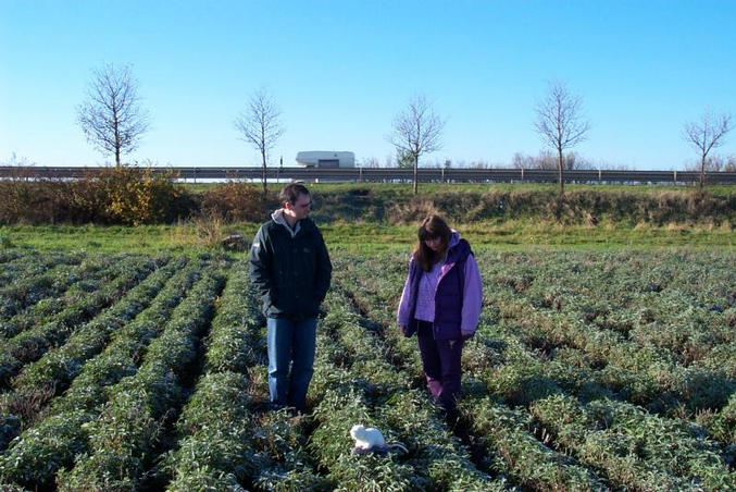
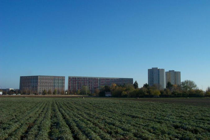
(visited by Andreas Tietze, Andreas Faulstich and Thomas Hanke) 04-Apr-2002 -- Ostern besuchten wir Andreas Faulstich's Eltern in der Rhoen. Wir hatten dort drei herrliche Wandertage mit Zeltuebernachtungen in den Bergen (http://groups.msn.com/andreas1tietze/wandern.msnw). Fuer die Rueckfahrt nach Berlin hatte ich noch zwei Mitfahrer aus Erfurt ueber http://www.mitfahrzentrale.de organisiert. Treffpunkt war die Paedagogische Hochschule. Diese sollte sehr nahe dem CP liegen, was ich aus der "Map-quest"-Karte wusste. Diese Gelegenheit kann man sich natuerlich nicht entgehen lassen! Da ich auf dem Weg nach Erfurt keine detallierte Karte dabei hatte, versuchten wir mal mit der Busch-Auto-GPS-Navigation durch Erfurt das Ziel zu erreichen (nur mit Wegpunkt 51N 11E, ohne intelligente e-street-map). So tappten wir in dem unbekannten Strassenlabyrint auf dierektem Luftlinienweg in so manche Falle: zum Beispiel Parkplaetze und Einbahnstrassen. Die Zeit wurde knapp, und so luden wir erstmal die Mitfahrer ein. Diese wurden schnell von der ausserordentlichen Wichtigkeit des CP-Projektes ueberzeugt. Wir brauchten nur noch die Nordhaeuser Strasse einen Kilometer nach Norden zu fahren und bogen in die Augsburger Strasse links ein. Vom Obi-Parkplatz ging es dann zu Fuss weiter. Unsere schlecht deutsch sprechende asiatische Mitfahrerin verstand nur Bahnhof, und zog es lieber vor im Auto zu warten. Thomas hingegen war sehr interressiert. Der CP sollte auf den von Hochhaeusern und Strassen umrandetem Feld liegen. Wir latschten gleich munter querfeldein. Als erstes trafen wir einen Mann, den wir irrtuemlicher Weise fuer den Besitzer des Feldes hielten. Er wurde gleich ueber den ueberaus wichtigen geographischen Schnittpunkt aufgeklaert. Auch er verstand nur Bahnhof. Wir koennten ruhig weitergehen, er wolle nur Gruenzeug fuer seine Hasen sammeln. Und da standen wir schon in dem Salbeifeld, als der Besitzer des Feldes in einem roten Auto erschien und uns vom Rand des Feldes misstrauisch musterte. Andreas Faulstich klaerte ihn auf, und ich nullte inzwischen das GPS. Der Punkt liegt ca. 20m oestlich der Schnellstrasse. Nach unserem Besuch fuhren wir weiter nach Berlin. Wie sich bei Betrachtung der Photos herausstellt, haben wir exakt den selben Ort, wie Besucher Nr.2 aufgesucht. (vergleiche Photo v2-pic4 mit #1, und die Hochhausgruppe in den Photos v2-pic6 und #5). Besucher Nr.1 hat den Punkt auf der westlichen Seite der Schnellstrasse "Hannoversche Strasse" lokalisiert: Betrachte Photo v1-pic3 : markante Hochhausgruppe im Osten mit Schnellstrasse dazwischen (!) und Photo v1-pic1 mit Obi-Baumarkt auf der linken Seite (!). Hoechstwahrscheinlich hat er den selben Fehler gemacht wie bei Confluence Point 51°N 12°E und nicht WGS84 eingestellt. Lese auch Bericht vom 3. Besucher 51°N 12°E. Quod erat demonstrandum. Andreas Tietze, Andreas Faulstich. 04-Apr-2002 -- Easter we visited Andreas Faulstich's parents in the Rhoen mountain range. There we spent three wonderful spring days with hiking and camping in the mountains (http://groups.msn.com/andreas1tietze/wandern.msnw) . For the return trip to Berlin I organized two other passengers from Erfurt through a web agency for arranged lifts (http://www.mitfahrzentrale.de). We agreed to meet at the Pedagogic University in Erfurt. From map quest I knew that this was near a CP. And naturally I could not resist this opportunity! Since we did not have a map of Erfurt, we tried to reach the target by GPS navigation using the waypoint 51N 11E. But without intelligent e-map navigation system we got lost in some parking areas and trapped in one-way streets and lost some time. As time got limited, we first picked up our passengers. We convinced them to join the extraordinary opportunity to visit a Confluence Point. We only had to drive northwards at the Nordhaeuser Road for one kilometer and turn left into the Augsburger Street. From the parking lot of OBI DIY store we continued by foot. Our first passenger, an asian female student did not speak a lot german and we didn´t succeed to convince her to leave the car. But Thomas who happens to be a travel guide was very interested. The CP was on a field surrounded by multistoried building blocks and roads. And we traipsed cross-country over the field. First we met a man, whom we regarded to be the owner of the field and we tried to explain our project. But he didn´t understand and said he only wanted to collect some greens for his rabbits. We had already entered the sage field, when the actual owner turned up in a red car. From the edge of the field he examined us suspiciously. Andreas Faulstich went to him and explained our exercise. In the meantime I zeroed my GPS. The point was about 20m east of the motorway. We took some photos and resumed our journey to Berlin. Later we compared our photos with those already in confluence.org and we realised that we were on the exact point as the second visitor. Compare photo v2-pic4 with #1, and the building blocks on photo v2-pic6 with #5. However, the first visitor localized the point on the western site of the motorway "Hannoversche Strasse". Photo v1-pic3 with group of building blocks in the east and motorway in between (!) and photo v1-pic1 with OBI DIY store on the left side! He made the same error at Confluence Point 51°N 12°E. Most likely he did not adjust WGS84. Read also story from Visitor3 51°N 12°E Quod erat demonstrandum. Andreas Tietze, Andreas Faulstich |
| All pictures |
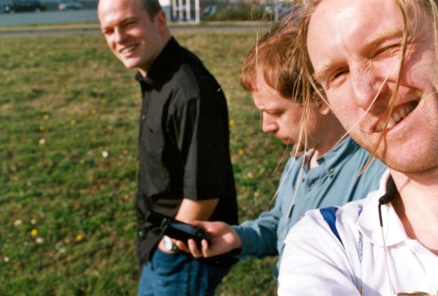
| #1: owner in red car - Andreas F - Thomas on CP #2: offroad-car-GPS-navigation in Erfurt #3: Thomas - Andreas F and me cross country #4: false owner with rabbit-food in his hand #5: GPS, view E, markant block-habitats in background #6: CP, view S, highway - Andreas F - Thomas ALL: All pictures on one page |